Guntersville Lake Watershed Before TVA

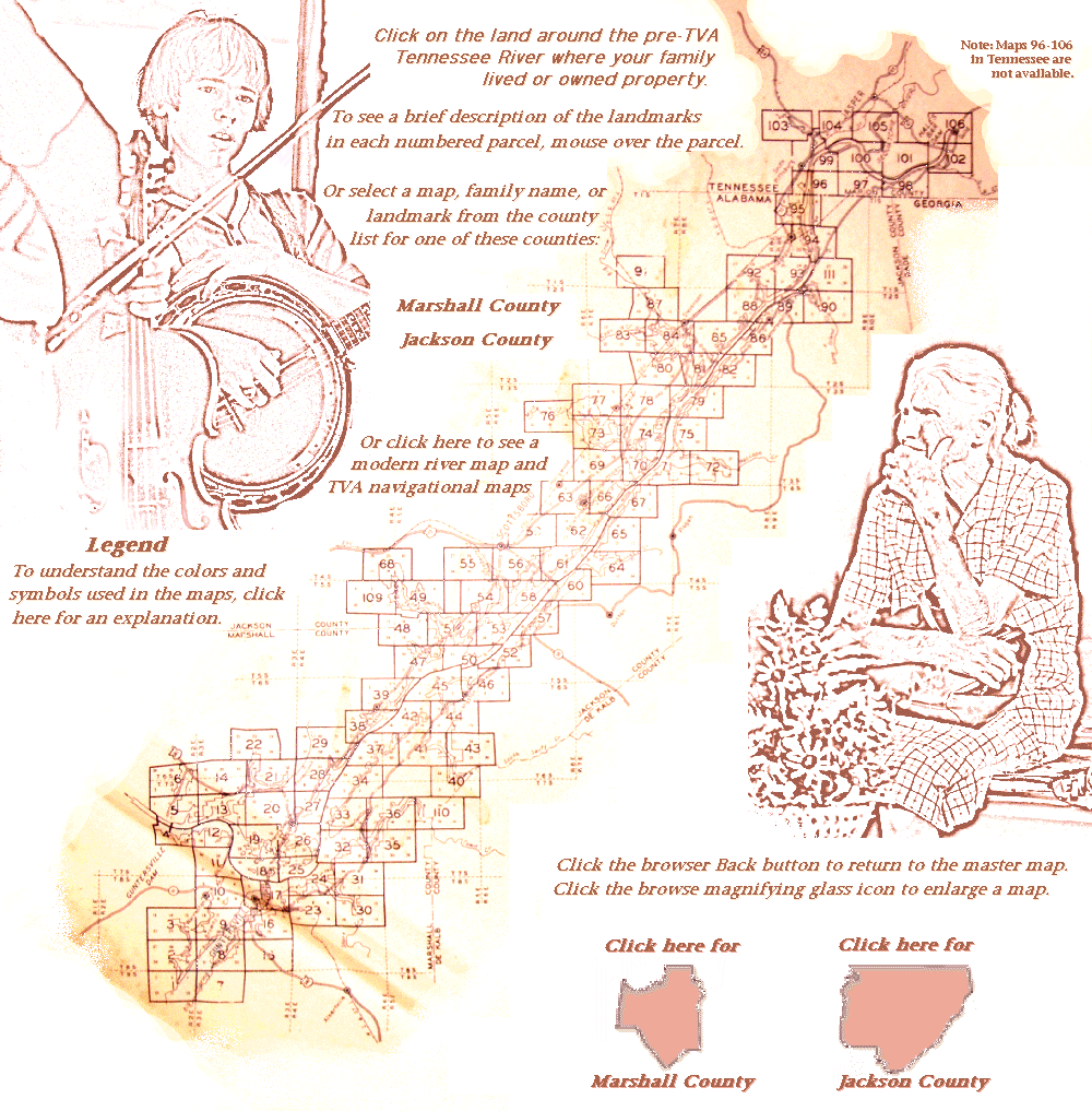
Alabama's Marshall and Jackson Counties and the Tennessee River before the TVA reshaped the valley in 1934...

Send comments or corrections on this Web site to Annette Bradford Maps 96-106 in Tennessee are not available. Marshall County adjacent to the Guntersville Dam Marshall County near the Guntersville Dam Beech Creek, Long Hollow Branch and Shoal Creek Hambrick Light and Dayboard Safety Harbor, Lock Tender's Reservation, and Harbuck Light Brown's Creek Big Spring Creek Warrenton School District area on the west side of the U-shaped bend of the original river in Marshall county Cooley Cemetery, Walker Light and Dayboard, Hayes Branch, Deposit Light and Dayboard, and Honeycomb Light and Dayboard Cottonville School, Cemeteries No. 15 and No. 33, Honeycomb Church, Honeycomb Creek, Honeycomb Light and Dayboard, a Safety Harbor, and a TVA Transmission Line Cemetery No. 13, Honeycomb Church, Quarry Site, a Southern Bell Telephone and Telegraph Line, and a TVA Transmission Line Mt. Hebron Church, Little Paint Rock Creek, and Highway 190 Map not available Map not available Guntersville, the Cage House and Submarine Cable, Cemetery No. 17, the Main Outfall Sewer Line for Guntersville, Moore's Hill, Polecat Creek, Rehobeth Baptist Church, Spring Creek, and a TVA Transmission Line islands around Guntersville, John Gunter's Reservation, and a Southern Bell Telephone Line Deposit Light and Dayboard and the Methodist Episcopal Church South no idea and a Southern Bell Telephone Line Honeycomb Creek, Jagger Branch, and a TVA Transmission line details about the Jagger Branch area Moore's Hill, the Nashville, Chattanooga,  and St. Louis Railway and Signal Line, Polecat Creek, Rehobeth School, and a TVA Transmission Line where Town Creek meets Smart Creek, including a Fishing Camp and Moore's Hill area around Buck Island area around Seibold Creek, including Claysville School, Hanaville Church, Clayville Baptist Missionary Church, Seibold Light and Dayboard, a Southern Bell Telephone Line, and a TVA Transmission Line Seibold Creek, Hanaville Church, the Harrison's Reservation, and Kennamer Cemetery Prospect Church, a Safety Harbor and a Safety Landing, and a TVA Transmission Line Mt. Hebron Church, Little Paint Rock Creek, and Highway 190 Big Spring Creek Embayment Chandler Branch, Chandler Cemetery, Columbus City School, Columbus Ferry Light and Dayboard, Cumberland Presbyterian Church, Millpond Creek, Prospect Church, and a TVA Transmission Line details of the Short Creek area details of the Short Creek area Minky Creek, Seibold Light and Dayboard, and Town Creek Minky Creek and a State Park Columbus Ferry Light and Dayboard and Mt. Moriah School the intersection of Hurricane Branch and Town Creek, including a Fishing Camp details of Town Creek with Minky Creek along the Marshall-DeKalb county line area north of Town Creek, including the Grantham Cemetery land on the Jackson-Marshall line including Highway 32, McCamy Light and Dayboard, Mink Creek, Preston Cemetery, a Safety Landing and a TVA Tranmission Line Jackson-Marshall line south of Langston Jackson-Marshall-Dekalb juncture near Yellow Creek portion of the river in DeKalb County, Burgess Creek, a Kirby Cemetery, the Mariman Hole Bridge, and Town Creek part of Marshall, Haygood Church, Sandridge Church, South Sauty Creek parts of Marshall and South Sauty Creek mostly Marshall and South Sauthy Creek This map is not available. This map is not available. This map is not available. Gross Cemetery, Meander Road, New Hope School, and Pleasant Hill Church Arthur Burns Reservation and New Hope School Archie Creek, McCutchen Church, and North Sauty Creek North Sauty Creek and Creek Channel, Larkins Light and Dayboard and Safety Harbor Meander Road, North Sauty Creek and its channel, and Temperance School area just north of the Marshall County line, Aspel Chapel, and a Subscribers Telephone Line Blue Spring Branch, North Sauty Creek Drainage, Subscribers Telephone Lines, and Jennies Chapel Caldwell Light and Dayboard where Roseberry Creek opens into the Tennesse River Roseberry Creek and Pierce Cemetery Roseberry Creek Randell Chapel Dianey Cemetery, Dry Creek Embayment, McHenry's Reservation, and Tiffin Private Cemetery Dianey Cemetery, Dry Creek Embayment, McHenry's Reservation, and Tiffin Private Cemetery Map not available Chisenhall Cemetery and Comer Bridge Chisenhall Cemetery and Comer Bridge Map not available Bellefonte Cemetery, Texas Creek, and the Harden, Morgan, and Rilee Reservations Bellefonte Cemetery, Texas Creek, and the Harden, Morgan, and Rilee Reservations Chisenhall Cemetery and Comer Bridge Focus is poor on some sections and many names are not readable. Jones Creek/Cove the area across the river from Bellefonte, including Sublett Ferry and the Athens Creek Light and Dayboard Map not available Abandoned Incline Railway, Bellefonte Island, and White's Ferry Light and Dayboard Martintown School, Out Fishcamp, Providence Church, Southern Railway, and Town Creek Coffey Ferry Light and Dayboard, Coffey Landing Ferry, Mud Creek, and Mud Creek Light and Dayboard Coffey Ferry Light and Dayboard, Deal Creek, Mud Creek Light and Dayboard, and Raccoon Creek Raccoon Creek Mud Creek and the Southern Railway Line Colored Public Cemetery, Fackler, AL, Holder Cemetery, Mud Creek, and Price Cemetery Coffey Landing Ferry, Deal Creek, and McCoy School Kyles Spring Branch and Mud Creek Western Union Telegraph Lines and Southern Railway lines near Stevenson Wannville area, including Western Union Telegraph Lines and Southern Railway and Signal Lines and the TVA tranmission lines and Alabama Power Company lines near U. S. 72 (1934 route) Crow Creek Channel, Crow Creek Island, Crow Creek Island Light and Dayboard, and TVA Transmission Lines Out of focus Caperton's Ferry, Crow Creek, Crow Creek Island, Crow Creek Island Light and Dayboard, and John Baldridge's Reservation  the area around Raccoon Creek including Caperton's Ferry, Marshall Branch, and the Old Fabius Church Coon Creek, Little Coon Creek, and Russell School Stevenson, including Benges Creek, Crow Creek, Private Telephone Line, Southern Railway, TVA Transmission Line, and Stevenson High School Stevenson, Evening Star Church, McMahan Light and Dayboard, Rudder's Chapel, and TVA Transmission Line Stevenson area and McMahan Light and Dayboard Big Coon Telephone Line, Centennial Church, Crow Creek, Crow Creek Church, Crow Creek (old channel), Nashville, Chattanooga,  and St. Louis Railway Signal Line, TVA Transmission Line, and Western Uniton Telephone and Telegraph Line area just north of Widow's Creek Steam Plant Long Island, Long Island Creek, a Safety Harbor, Widow's Bar Lock, and the Widow's Bar Light and Dayboard the area on the south side of Long Island Map not available the Nashville, Chattanooga,  and St. Louis Railway and Signal Line, Widow's Creek, Southern Bell Telephone and Telegraph Company, TVA Transmission Lines, and the Western Union Telegraph Line Reese Ferry, Reese Light and Dayboard, a Safety Harbor, and the TVA Transmission Lines Bridgeport, AL and its City Limits, Island Bar Light and Dayboard, Long Island, Nashville, Chattanooga,  and St. Louis Railway, Southern Bell Telephone and Telegraph Company, TVA Transmission Line, and Western Union Telegraph Company area north of Bridgeport to the Marion County TN line, Jones Creek, Nashville, Chattanooga,  and St. Louis Railway and Signal Line, a Private Ferry, Southern Bell Telephone and Telegraph Company lines, and Western Union Telegraph Company lines area near the Tennessee Line, a TVA Transmission Line, Reese Ferry, and Reese Light and Dayboard Marshall County Jackson County Marshall County Jackson County Modern Navigational Maps legend


Final Version of the TVA Maps

Click here to display a list of the final maps. Or to see the maps in the context of the working maps, see the named link at the end of each map name from the list below.